What is Terrestrial Laser Scanning?

June 9, 2020
What is Terrestrial Laser Scanning?

esmith |
What is Terrestrial Laser Scanning?
3D Laser Scanning is a non-contact, non-destructive technology that digitally captures the shape of physical objects using laser light. 3D laser scanners create “point clouds” of data by scanning over them with laser light. In other words, 3D laser scanning is a way to capture a physical object’s exact size and shape into the computer world as a digital 3-dimensional representation.Getting the 3D Data
The first step in getting a 3D building is gathering the 3D information. Traditionally this was done using manual measurement techniques. More recently this work has been almost entirely replaced by laser scanning. The reason for this shift is two fold; first the cost per square foot has dramatically reduced while the quality of the data has increased by over 10x. These two factors have lead to a dramatic shift in data acquisition since 2010.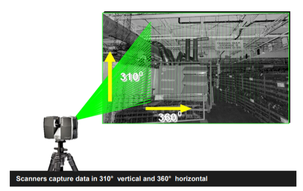
Data Acquisition
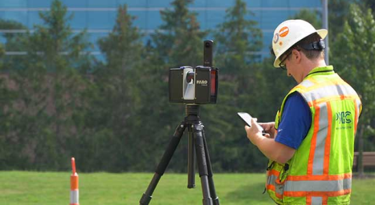
For most projects a single scanner is used. A modern scanner is a small piece of equipment that sits on top of a standard camera tripod. The scanner will be setup multiple times throughout the building or facility to be scanned. Depending on the project size you should expect to see anywhere from 20 to over 1000 individual setups. Each time the scanner is run it will take from 2 to 10 minutes depending on the settings used.Scanning Output
The shape of objects appear as millions, or even billions, of points called a “point cloud”. The point cloud is viewed on and processed on standard workstation class computers. The process is very fast, gathering up to 1,000,000 points per second and very precise over large areas (to ±0.12″). Scan data is commonly used in most major CAD applications including all Autodesk and Bentley products. The scan is used as a reference to create model geometry for use in project planning or sometimes just on it’s own as an accurate record of as-built conditions.Laser Scanning Process ROI
- Accurate and exact measurements
- All data is captured
- Advanced decision making
- Data is quickly available to entire team
- Clash detection
- Reduce costs and schedule savings
- Safety
- Reduce job site interruption
More Than a Planning Tool
One common use within the AEC industry is to ensure that what was promised is what was delivered. This can be used a various stages of construction to accomplish different goals. It is often used a quality check to ensure that installers are meeting there obligations to ‘build to the model’. Another great use is to capture conditions before they are enclosed. Have a 3D scan of piping before it is encased in concrete can be a great asset for a building owner to posses.About PMC
PMC is the largest independent industrial engineering & simulation services firm in North America. For over 30 years PMC has been leveraging the latest in advanced technology to improve our Client’s processes. Established in 1979 PMC, has grown to have office around the world. With over 700 clients, 6000 completed projects, and over 150 employees PMC can work with you to find the right data-driven productivity solutions for your needs.Let our experts show you how our Services can support your projects!
esmith
Recent posts
Material Flow and Analysis Explained
Read moreYou may also like