Understanding Point Cloud Alignment & Coordinate Systems
Point clouds live somewhere in space, where they are in space are based on something called a coordinate system. In today’s post, we will keep the math to a minimum and approach coordinate systems from a practical, applied approach. In the world of CAD and point clouds, coordinate systems are defined by an X, Y, Z origin point, and a Z-axis rotation. When a point cloud is first registered, the origin and rotation are based on where the first scan was taken. This is seldom a good location as it is very arbitrary. To produce a useable point cloud, we need to put the point cloud on a rational coordinate system that the whole project team can use.
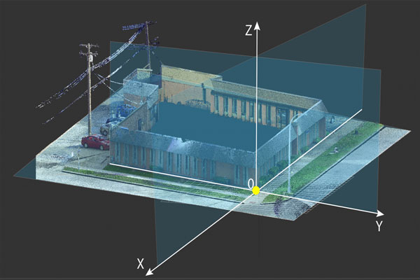
We assume that your building is relatively flat and level. If it is not, we need to talk.
When we say relatively we mean that the main floors of the building would be flat within +/-1″ at any measured point.
How do you know what coordinate system to use? That is easy; PMC will ask a couple of questions to understand better what coordinate system is required for your project once scanning is complete. We do our best to break it down into a few simple questions.
Before we begin
Typically buildings will have some drawings or plans originating from construction. When there is existing CAD/BIM data of the building, it can be used as a reference for the point cloud data’s alignment. Generally, this is the preferred option for most teams. Aligning to your existing CAD/BIM data ensures that the existing data can be used without a need to shift it in the CAD/BIM environment.
If your building is ancient and there are no existing CAD/BIM drawings, no need to worry. We can work with that.
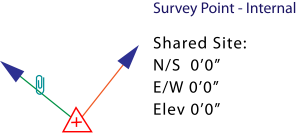
While AutoCAD and Microstation straightforwardly handle coordinates, Revit can have a Shared Coordinate added.
If your Revit model is using Shared Coordinates, please let us know.
Have a survey file you want us to use? We should have already talked about that, oops.
Please stop here and contact us.
It starts with a question
The first question you will be asked is, can you provide a CAD (DWG/DGN) or Revit model of the scope area? If you answer this yes, you will be almost done. We will have one more question for you. No worries though, even if you answer no, there are just a few more questions.
PDFs can not be used for alignment, only CAD/BIM data. If you don’t have a file, it’s not a problem.
There are just a few more questions we’ll need to ask.
A simple Yes or No
If you chose yes to the first question, keep reading. If you chose no, skip to the next section.
You’ll be asked, do you want PMC to perform the best fit of the point cloud to the provided CAD or BIM file? What does that mean? It means that PMC will align your point cloud to the provided CAD or BIM file. Given the difference between the actual built environment and the assumed world of CAD, your point cloud will be centered within the CAD data and not aligned to any one benchmark. If you want to lock the point cloud to one specific point in the building, you need to pick no to this question. Some examples of this desire to have the origin be the center of a building column or a building corner.
You chose NO, now what?
You will be asked two additional questions to help define the origin and rotation of the point cloud. We’ll start by asking about the X/Y location then rotation. We provide the most common answers for you to pick from, but you can always choose to customize it. We know that every project of the built world is unique and will often require unique solutions.
X/Y
Q: For the X and Y-axis origin (North and Easting), how do you want the point cloud aligned?
A: Here, we ask you what point within the point cloud do you want X=0 and Y=0 to be. Typically this is some logical point in the building, like a corner. Sometimes it can be a known benchmark point like the center of a fire hydrant.
Rotation
Q: For rotation of the point cloud, please select what you would like.
A: In the first question, we locked in a 0,0 point, but we can rotate around that point. You likely don’t want your building to be rotated at 31.25 degrees, but what do you want it rotated too? The most common answer is to align the longest wall along the X-axis. You should consider how your project will fit your sheets and if having a project north or true north is important to you.
The Z-axis or Elevation?
We’re almost done here. We need to sort out elevation. What we need to know is, what do you want the elevation of the first floor you walk on when entering the front door to be? The most common answers are 0 and +100. Sometimes we are asked for sea level. We will take multiple measurements across that floor and average them to set the elevation.
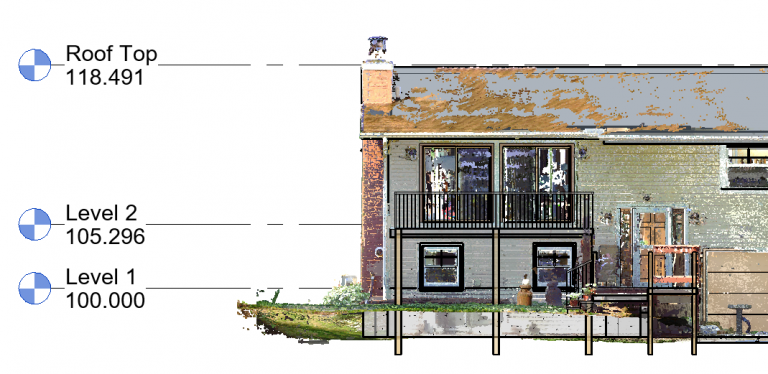
If your building has multiple “main doors” to different floors or you think we may be confused by what the “front door” is, please reach out to us.
Wrapping it up
You’re done! We know how to align your data and it will be in your hands shortly! Have concerns still? Worried we don’t know what you mean? No problem, the form is not meant to replace talking to one of us. If you have any concerns at all we are here to help. Please feel free to reach out at any time to the team at PMC.
Let our experts show you how our Services can support your projects!
Recent posts


